
In high school, Christopher Lee got into lots of trouble for talking too much.
“Now, they pay me to talk!” The UNT Eagle Ambassador explains that he loves giving tours to prospective students and really just loves being social. That would explain his recent election to the vice presidency of the UNT Student Government Association.
A few things you may not know about the newest SGA VP are that when Christopher isn’t giving tours or hanging out in the president’s box at football games, he is really passionate about forestry – urban forests in particular. Lee is also a photographer, keeps a rather large map collection, and is fascinated by the idea of location – where we put things and how we keep track.
News@xREZ caught up with Christopher (just moments before he had to dash off to give a campus tour) to talk about his interests spanning geographic information systems, photography and geography, and a little about his project at xREZ Art + Science Lab using the rePhoto app to monitor trees.
Lee also tells us why labeling your discipline can be confining and “just trying it out” can open doors.
Amelia Jaycen: So, Christopher – You Won! Congratulations, Mr. Vice President.
Christopher Lee: Yes! I’m Vice President and my running mate Adam Alattry is President.
A: So what will your job be exactly?
C: We are the part of student government that talks to the administrators so that we can be the voice for students to the administrators. But we also want to be the voice from the administrators back to the students. So we’ll facilitate that dialogue going back and forth. Communication is key for anything to run smoothly, communicating issues, topics, whatever it may be back and forth between administrators and students.
A: Very cool. You’ll be a great VP! So, you joined xREZ this fall. How did you end up here? I think there’s a lot of value in that because scientists can see the data and artists can see the visual representation of an idea. If you collaborate between those two things you can get an amazing result. And I think that’s really what this lab is all about.
C: A professor in the photography department mentioned it because I told her that I was very interested in geography and photography and she said, “Hey there’s an opportunity where you can combine those two and do something with it.” I was like, “Awesome!” So from there she introduced me to Professor West and she put me on the rePhoto project, and I’ve been working my way through that since.
A: So tell me more about your interest in the combination of geography and photography.
C: I really like the ideas of location. Location-based anything. That’s one of the reasons I’m interested in geography. But I’ve always loved maps. I love mapping. I Iove the idea of why things are where they are, the reasons behind placing things in certain ways. I’m fascinated by the idea of location in every sense of the word, so I keep going back to that idea.
A: But you’re a photography major?
C: Yes, with a minor in geography, and I’m getting a certificate in geographic information systems.
A: How did you get interested in geography?
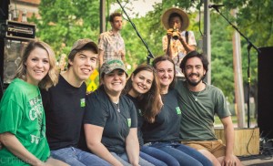
Christopher Lee (right), VP of the Country Western Dance Club, pictured with the executive members at a 2014 UNT Zane Williams concert.
C: I came into college wanting to be an art teacher and figured out you had to be a special kind of person to do that. I was not that special kind of person. So I stepped back and focused on photography. And then I was trying to figure out how to get paid if I can’t do this whole art thing. It was kind of a mid-college crisis, asking, “What am I doing with my life?” And then it came back to my love of maps.
I’ve collected antique maps for years, so I just have a love for that. And I thought “Hey maybe I could study something along those lines.” Forestry and the forest service and firefighting are all kind of like other interests of mine. So I thought I would try this out, and I’ve really enjoyed what I’ve learned in my geography classes since. That’s how most of my college career has worked out – just trying things to see what happens, and it’s always worked out.
A: So you know you don’t want to be an art teacher, but do you consider yourself an artist?
C: I do. I think “artist” is a strong word sometimes. I like the word “creative.” I think being a creative and having a creative mindset is different than being an artist because being a creative means you can still work within other disciplines and just have a different mindset going into those disciplines. So I think that’s more so what I see myself as, because I’m involved with anything from Greek life to student government and housing on campus, and then I’m doing art in the middle of all that and studying a science. So it’s hard for me to define myself as an artist. Defining myself as a creative is a little bit more appropriate.
A: So do you consider yourself a scientist?
C: I don’t think I would consider myself a scientist. I think if anything, it goes back to being a creative. I would consider myself a creative because it’s hard for me to put a label on something when I’m involved in so many other things. It’s easier to say one word instead of list 30, so I think that encompasses all of that.
A: So how did you become aware that other options were available to branch out into sciences?
C: It was just kind of something that happened. It goes back to just trying something, just figuring it out. See if it works. If it doesn’t work, move on from there. But that’s kind of how that all started, I figured I’d just try it.
A: So it sounds like you’re pretty sold on the combination of art + science?
C: Yeah, I think it’s definitely a valuable thing and coming from the mindset of being a photography and geography and also being a self-defined creative, I think there’s a lot of value in that because scientists can see the data and artists can see the visual representation of an idea. If you collaborate between those two things you can get an amazing result. And I think that’s really what this lab is all about, the connection of those two things. But it’s just a matter of breaking down those walls and those barriers between science and art and trying to figure out how to do it.
I think “artist” is a strong word sometimes. I like the word “creative.” I think being a creative and having a creative mindset is different than being an artist because being a creative means you can still work within other disciplines and just have a different mindset going into those disciplines.
A: So tell me more about the rePhoto project that you’re doing @xREZ?
C: We’ve worked through a couple technical difficulties for the first part of the semester. What we’re working on now is a lot of data collection, so were taking photos of trees, and we’re trying to figure out whether there a way that we can document change in two dimensional images and incorporate that documentation with a 3-dimensional model.
So we have Lidar which is a 3-dimensional model of the ground surface, and from that we can get tree canopies and get different elevation models, but Lidar capture doesn’t happen very often, once every 5 years or so. But with the rePhoto app you can take pictures every day, and you can have a constant model to show the change.
But the couple of issues that we’re trying to figure out are whether the functionality we’re trying to build is best used for management or where it fits into the whole spectrum of applications. I’m focusing on how to use those 2-dimensional images to document or see change. So I’m asking what exactly it is that we’re seeing in these images that is changing over time.
I also struggle with the photography side of it because training in photography you try to take a good image, well exposed, in focus, all of that. Using these mobile apps to take photos you can take it out of your pocket, point it at the tree, click, you’re done, put it back in your pocket. It’s a pretty different kind of photography from fine art, which was my training.
A: Have you ever tried to think of a way for rePhoto to work with high-quality images?
C: I have. There’s actually something called computational re-photography, and there’s some really cool information there, and it has to do with this software that will actually scan the image and tell you where to stand exactly to re-create that image. I’ve been reading Mark Collette, he is a photographer you could call the pioneer of modern re-photography, he’s definitely the leading person as far as that is concerned, so I’ve been looking into his work. One of our professors, Paho Mann worked under Mark, so he’s feeding me stuff to read. Mark Collette is very precise. He’ll go to the exact time of year the exact time of day, the exact everything to recreate images.
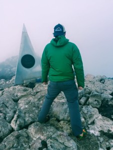
Christopher Lee atop Guadalupe Peak, the highest point in Texas, during spring break 2014.
I’m working and trying to see the ideas behind re-photography. One of the other things that I’ve been thinking about in the middle of all of this is asking: Are we recreating images? Is it images that we’re dealing with? I don’t think re-photography is the right word to be using for this, because there’s so many ideas behind documenting this way. Sure, the idea is taking the same image over and over again, yes, that is re-photography. But the ideas behind it are actually kind of broad.
A: Okay, so tell me about your use of GIS, Geographic Information Systems?
C: The GIS is a software that every geography person probably knows about or has at least heard about, if not uses it. GIS is all about spatial analysis. So analyzing points, you can analyze water sheds, elevation models – there are thousands of things you can do but it’s all for geography. Land use models, mapping campus, the buildings, all that can go into a GIS system
A: Like a 3D modeling system.
C: It can be a 3D modeling system, it’s also 2-dimensional maps, a lot of maps. So there’s a lot of things you can do within this software. In this project we’re using it mainly for the LIDAR purpose, because that data you process through the GIS software. So we have all that information, and we’re using it.
A: So is the plan to get a survey of all trees at UNT?
C: Right now we’re doing a little pilot study on a couple of trees here on the library mall. And what we’re focusing on those trees is can we figure out what we’re monitoring on them.
A: Is it related to the health of the tree?
C: It can be. Urban forestry is a huge movement. Urban greening, getting those urban spaces green, monitoring urban forests is a huge movement right now. Urban foresters are overwhelmed with the number of trees and the policies and regulations, so to have something like this, where you can see that this is the tree, this is what’s changing over time, where you can take photos really benefits urban forestry. But at the same time, what other ways can it benefit? How can we incorporate that into something they already use, like GIS? So you can have databases of all the trees, location of the trees, the type of trees, the diameter, all those things that we need to have, those statistics on them monitored constantly, and then a photograph of them too, a visual representation. How can we incorporate all of those things together?
A: I got a tree survey in the mail from the city of Denton. Do you know anything about the city’s survey system?
C: I don’t know exactly. I would like to meet the urban forester of the city of Denton, but I haven’t met him yet. It would be cool to sit down with him and ask him: As an urban forester, what is it that you’re monitoring, what is it that you’re looking for, what are your needs? How can what we’re doing benefit those needs in any way?
A: So I’ve seen you giving tours to people on campus – looks like fun!
C: Yes, I’m currently I’m an Eagle Ambassador, and we give tours to people on campus, and we work in the president’s office. That’s a lot of fun. I apparently really like to talk to people. So I really enjoy that. Being social is one of my strong suits. It’s funny in high school I got yelled at all the time for talking, and now they pay me to talk to people, so it’s great!
A: So SGA, Ambassador, Greek life, photography, geography, and GIS – anything else we’re leaving out.
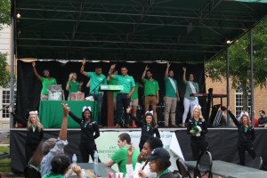
Christopher Lee as a UNT Eagle Ambassador leading students in the fight song and alma mater at UNT’s University Day in spring 2014.
C: That’s pretty much it. I do have the dream of being the Student Regent here on campus, to be the student who sits on the Board of Regents for the UNT system, which I think would be really cool. It’s kind of a big dream, but we’ll see if we can make that happen.
A: That is a big dream. But dreaming big is good right.
C: Thanks! Yeah, I have to run. I give a tour to FEMA, or they’re representatives from AmeriCorps that I have to give a tour to today. It’s not something you get to do every day!
A: Wow! Neat. Good luck, Christopher!
About Christopher
Major: Photography, Minor in Geography
Dream Job: Map-maker and politician.
Hobbies: Map collecting, hiking.
Fun Fact: Working on developing his own Texas “brand” to represent the C, L, & T in his name.
Check out Chris’ recent activity at the Student Government Association
News@xREZ Dec. 7, 2015
Update!@xREZ May 12, 2016 Alumnus Christopher Lee Appointed UNT System Student Regent